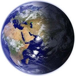
EarthView turns the desktop background or screen saver into a generated view of Earth. It can show a flat map or a globe, move the viewpoint, and shade the surface according to daylight. Night areas reveal city lights, while daytime views can include atmosphere, clouds, water, vegetation, snow, and sea ice. EarthView is a visual desktop display, not a navigation map or an interactive satellite service.
The image changes with the time of day and the selected viewpoint. A user can frame one continent, place a chosen city near the center, or show most of the planet. Saved views and profiles make those choices reusable. Multiple-monitor support can place Earth imagery across more than one screen without requiring the same crop on every display.
Day meets night
The daylight boundary is the central part of the image. EarthView calculates which parts of the globe face the sun and darkens the rest. City lights appear on the night side, and atmospheric effects soften the edge. Seasonal maps can change vegetation, snow cover, and ocean ice across the year instead of keeping one permanent surface image.
This calculation is not the same as a live photograph of the whole planet. The base surface comes from prepared map data. EarthView combines that surface with calculated light and optional downloaded layers. A cloud pattern can be current while the ground beneath it remains part of the selected map set.
Clouds need data
Current clouds require an Internet connection. EarthView downloads the cloud information and applies it to the next rendered view. If that request fails, the program can still create a wallpaper, but the cloud layer cannot represent the latest available data. The same distinction matters for weather information: a decorative Earth image does not prove that every displayed condition has refreshed.
The city database supplies names, local times, and weather locations for more than 140,000 places. A city can become a label or a viewpoint rather than merely a bright dot. Dense labels can crowd a wide map, so a useful profile usually limits the displayed cities to those that matter for that screen.
Map detail
EarthView lists five base maps with different surface treatments and levels of detail. The first seasonal map has a stated scale of 10 kilometers per pixel at 100 percent zoom. That can look clear when the full globe fills the screen, but close crops reveal the limit. Higher-detail maps improve a regional view and consume more storage.
The demo includes only the first map. Other map files come as separate downloads, so installing the main program does not place every advertised surface on the computer. A user who moves a profile to another machine needs the same map files there or must select an available substitute.
Profiles and screens
A profile holds a combination of view, map, labels, and display behavior. This is useful when the wallpaper should show a home region during work but the screen saver should rotate through wider views. Profiles also prevent repeated adjustment after experimenting with another projection.
EarthView generates image files and assigns them through Windows desktop or screen-saver settings. A third-party wallpaper manager can compete for the same setting and replace the image after EarthView changes it. Likewise, a computer that sleeps before the screen saver starts may never show the screen-saver view. Those behaviors belong to the desktop configuration, so changing an EarthView interval alone may not solve them.
What stays static
The program can make Earth appear active without becoming a scientific viewer. It does not expose measurement tools, route planning, or free movement through raw satellite tiles. Its focus stays on a prepared desktop scene. The best results come from choosing a map whose detail matches the crop, confirming that online layers refresh, and saving the finished combination as a profile before changing the view again.